CORE VALUESHIRE US

PRECISION, INSIGHTAND CONFIDENCE

REGISTERED SURVEYORS / MAPPING CONSULTANTS

LIAHONAGEOSERVICES
PLANNING & APPROVALSSurvey plan requiredat e-Planning screening

Lagos screening guidance includes a survey planamong the core documents used to assess adevelopment application.

LAGOS ePP LIVE GUIDANCE

Liahona Geoservices capabilities

SURVEYING

Accurate, efficient and comprehensive surveying solutions supporting development and infrastructure projects.

  • ENGINEERING SURVEY: Topographical, route, setting-out and leveling surveys for roads, buildings and bridges.
  • AERIAL SURVEY: High-resolution drones and photogrammetric processing for mapping, inspection and 3D modeling.
  • HYDROGRAPHIC / BATHYMETRIC: Underwater mapping and data collection for coastal engineering, dredging and marine construction.

AERIAL SURVEY

High-resolution aerial capture and underwater mapping extend site intelligence beyond conventional ground observation.

  • AERIAL SURVEY: Drone mapping and photogrammetric processing for large-scale mapping, site inspection and 3D modeling.
  • SITE INTELLIGENCE: Spatial capture expands observation into measurable visual context.

CADASTRAL SURVEY

Boundary definition and environmental intelligence support secure land ownership, responsible development and regulatory decisions.

  • CADASTRAL SURVEY: Perimeter and layout design surveys define property boundaries and support land titling.
  • LAND TITLING: Survey evidence supports formal ownership and real-estate development.
  • ENVIRONMENTAL IMPACT: Risks and impacts are evaluated against regulatory requirements and sustainable strategies.

LAND SALES

End-to-end solutions for individuals, developers and corporate organizations seeking to acquire, manage or develop land.

  • SALES & PURCHASE: Buying and selling support with verified documentation for secure and transparent transactions.
  • LAND ADVISORY: Acquisition decisions informed by technical and documentation checks.
  • PROJECT CONSULTANCY: Land development decisions connected to technical project requirements.

LAND DISPUTE RESOLUTION

Technical survey evidence and land-use structuring help resolve ownership conflicts while optimizing allocation and regulatory compliance.

  • DISPUTE RESOLUTION: Technical survey data and legal frameworks support boundary and ownership dispute resolution.
  • SUB-DIVISION: Well-structured parcel layouts optimize land use and regulatory fit.
  • ALLOCATION: Plot distribution is organized for efficient and defensible land use.

LAYOUT DESIGN

International-standard layouts balance aesthetics, functionality and sustainability while project oversight protects specifications, budgets and deadlines.

  • LAYOUT DESIGN: Layouts for estates, industrial zones and agricultural developments optimize use, function and sustainability.
  • PROJECT MANAGEMENT: Concept-to-completion oversight coordinates technical requirements and delivery.
  • CONSTRUCTION MANAGEMENT: Execution is supervised against specifications, budgets and deadlines.

GEOSPATIAL DATA

Location intelligence is transformed through GIS technologies, aerial-data processing and analytical workflows into decision-ready information.

  • DRONE IMAGE PROCESSING: Raw aerial data becomes orthophotos, digital elevation models and 3D mapping outputs.
  • ORTHOPHOTOS: Geometrically corrected imagery supports reliable spatial interpretation.
  • 3D MAPPING: Three-dimensional site understanding expands project intelligence.

STRATEGIC MAPS

Spatial information is converted into strategic maps and analytical outputs for infrastructure planning, environmental management and investment decisions.

  • STRATEGIC MAPS: Detailed geographical maps support infrastructure planning, environmental management and investment decisions.
  • GIS ANALYSIS: Spatial-data analysis supports urban planning, utility management and resource monitoring.
  • PLANNING INTELLIGENCE: Location relationships become visible across complex systems.

CUSTOM GIS APPLICATIONS

Custom GIS applications automate data collection, analysis and visualization around real government and private-sector workflows.

  • CUSTOM DEVELOPMENT: Tailored GIS software automates data collection, analysis and visualization.
  • AUTOMATED WORKFLOWS: Field and operational data capture can be streamlined into structured systems.
  • VISUALIZATION: Maps and interfaces turn complex location data into usable intelligence.

COMPLETE CAPABILITY

Integrated surveying, land advisory and geospatial development capabilities connect measurement, ownership, planning and location intelligence.

  • SURVEYING: Precise field measurement and infrastructure support.
  • LAND ADVISORY: Secure transactions, dispute resolution and project guidance.
  • GEOSPATIAL: Data processing, mapping, GIS analysis and custom applications.

SURVEYING

ENGINEERING SURVEY

Accurate, efficient and comprehensive surveying solutions supporting development and infrastructure projects.

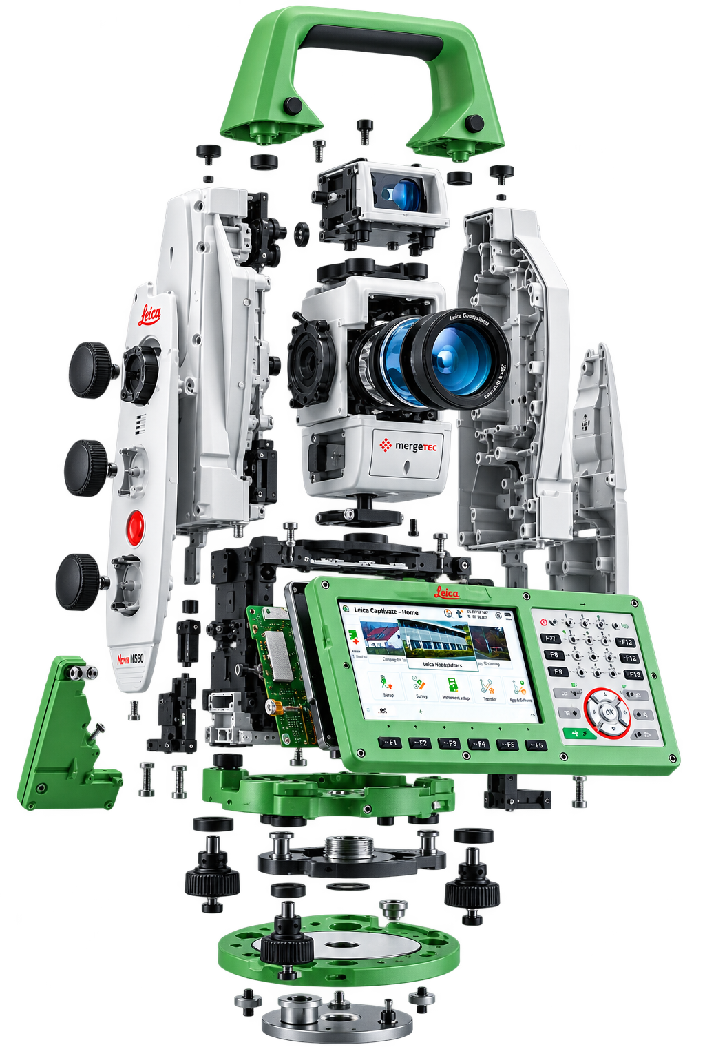
CADASTRAL SURVEYENVIRONMENTAL IMPACT ASSESSMENTHANDLE ASSEMBLY / ERGONOMIC TOP HANDLE

AERIAL SURVEY

High-resolution aerial capture and underwater mapping extend site intelligence beyond conventional ground observation.

HIGH-RESOLUTION CAPTUREMARINE DATAOPTICAL MODULE / PRECISION TARGETING

CADASTRAL SURVEY

ENVIRONMENTAL IMPACT ASSESSMENT

Boundary definition and environmental intelligence support secure land ownership, responsible development and regulatory decisions.

BOUNDARY VERIFICATIONREGULATORY EVIDENCELEFT HOUSING / FIELD CONTROL ACCESS

LAND SALES

LAND PROJECT CONSULTANCY

End-to-end solutions for individuals, developers and corporate organizations seeking to acquire, manage or develop land.

VERIFIED DOCUMENTATIONSECURE TRANSACTIONSRIGHT HOUSING / BATTERY & INTERFACE

LAND DISPUTE RESOLUTION

SUB-DIVISION & ALLOCATION

Technical survey evidence and land-use structuring help resolve ownership conflicts while optimizing allocation and regulatory compliance.

BOUNDARY EVIDENCEPARCEL STRUCTURELENS SYSTEM / LONG-RANGE PRECISION

LAYOUT DESIGN

PROJECT & CONSTRUCTION MANAGEMENT

International-standard layouts balance aesthetics, functionality and sustainability while project oversight protects specifications, budgets and deadlines.

INTERNATIONAL STANDARDDELIVERY CONTROLINTERNAL CORE / DATA & MEASUREMENT

GEOSPATIAL DATA

DRONE IMAGE PROCESSING

Location intelligence is transformed through GIS technologies, aerial-data processing and analytical workflows into decision-ready information.

LOCATION INTELLIGENCEDATA DEVELOPMENTDISPLAY MODULE / FIELD WORKFLOW

STRATEGIC MAPS

GIS ANALYSIS

Spatial information is converted into strategic maps and analytical outputs for infrastructure planning, environmental management and investment decisions.

INFRASTRUCTURERESOURCE MONITORINGROTATING BASE / STABLE POSITIONING

CUSTOM GIS APPLICATIONS

TAILORED GEOSPATIAL SOFTWARE

Custom GIS applications automate data collection, analysis and visualization around real government and private-sector workflows.

AUTOMATED WORKFLOWSDECISION INTERFACESTRIBRACH FOOT / LEVELING SUPPORT

COMPLETE CAPABILITY

SURVEYING / LAND / GEOSPATIAL

Integrated surveying, land advisory and geospatial development capabilities connect measurement, ownership, planning and location intelligence.

PRECISION IN MEASUREMENTINTELLIGENCE IN LANDCOMPLETE SYSTEM / ALL CAPABILITIES ALIGNED

06°27'N  /  03°23'E     •    LAGOS / FIELD INTELLIGENCE

DO NOT IGNORE A SURVEYOR ADVISE